
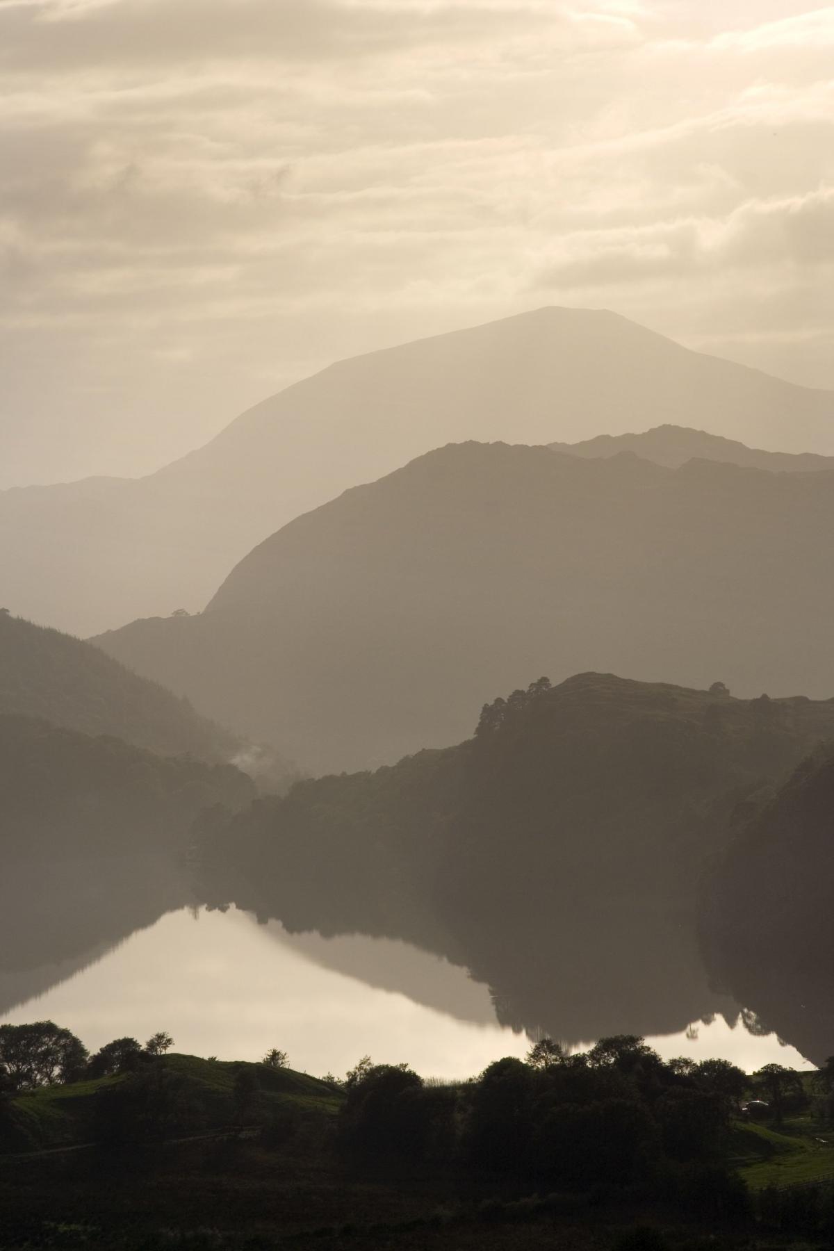
LLYN GWYNANT
AROUND a beautiful mountain lake with stunning views of Snowdon.
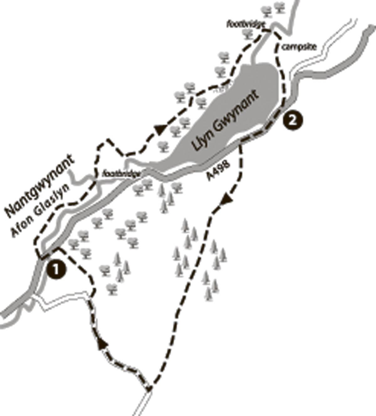
Start: Begin the walk at the National Park car park for the Watkin Path approach to Snowdon. This lies between Llyn Dinas and Llyn Gwynant on the A498.
Map reference: SH 628 507.
Distance: 9 kilometres/5½ miles.
Duration: Allow 3-4 hours.
Food and Drink: Nearby pubs and cafés in Beddgelert. Or, try the famous climbers' Pen-y-Gwryd Hotel at the junction of the A498 and A 4086. 01286 870211. Good picnic spots above the lake.
Map: OS 1: 50,000 Landranger 115 Snowdon; OS 1:25,000 Explorer/Outdoor Leisure OL 17 Snowdon.
The walk:
1. Turn left out of the car park, cross the bridge and in about 100 metres or so turn right into a narrow lane. Snowdon's Watkin Path starts here, entering the woods on the signed footpath ahead. Ignore this, walking along the lane instead to the footbridge on the right, in about 100 metres. Cross the footbridge and follow an attractive riverside footpath with views left across the meadows of Nantgwynant to Snowdon. At the end of the path where the river bends, cross a second footbridge.
Turn left for about 35 metres, then bear right through a gap in the wall. Walk ahead, slightly left of centre, through the following field to the top corner of the field where there are two gaps in the wall. Go through the left hand gap where a grass track passes through the wall. The track curves left here, but the path goes ahead parallel to the wall on the right, to the top corner of the field, where there is an old iron gate on the right. Go through the gate and follow an old pathway enclosed by stone walls.
Within 150 metres, the path turns right, enclosed by ruined walls now. Follow the path down to an old stone barn on the left
('Ysgubor Bwlch'). Cross the ladder stile by the gate and walk beside the river on a well-used footpath. Where the path swings right towards an old house, go ahead, passing to the left of a small tree-covered knoll, to a gap in the wall. The path now rises to a mound of rust covered stones - the waste from a small trial mine nearby. It is also an excellent spot to look for samples of iron pyrites or 'Fool's Gold'. The well-worn footpath continues to rise before descending a delightful secluded valley to pass a small ruin over to the right.
Cross a stile and a stream a little further on, then rise through the trees to a spectacular viewpoint overlooking the lake. The path
descends from here to a ladder stile over the wall close to the point at which Afon Glaslyn enters the lake. Cross the stile and
continue with the wall to your right, eventually passing through an area of huge fallen rocks. Turn right just beyond this over the
footbridge, which takes you into a campsite occupying the flat green fields at the head of the lake. Walk straight ahead to a ladder stile (but don't cross it), then turn right, following a fence line down to the water's edge. Turn left along the shore and follow the footpath to the road (A498). This dramatic valley has been used as the setting for a number of film productions, notably First
Knight with Richard Gere and Sean Connery, and Merlin, a TV production. Ironically, there is little of historic interest here
today - no major events are known to have taken place here and the only early remains consist of a Roman camp at the head
of the valley near Pen y Gwryd and the Dark Age fortress which existed at Dinas Emrys further down the valley towards
Beddgelert. One reason may be its location, deep within the mountain wilderness of Eryri in the heart of the ancient kingdom of Gwynedd. As such it would undoubtedly have been used as a safe retreat by the people of Gwynedd in times of trouble.
2. Turn right along the road and, after about 500 metres, look for a signed footpath on the left immediately after a milestone built into the wall. This follows a stony track beyond a gate which begins to rise before veering right after 150 metres or so. Leave the track here and go ahead up stone steps to walk beside the wall on the left. Higher up, where you meet the track again on a bend, keep ahead beside the wall as before.
Continue beside the wall to meet the track again - which you should now follow. The angle eases as you climb. Continue, to
pass through a gateway in the wall, and follow the track as it bends right towards farm buildings. Ignore the signed footpath
to the right immediately before the buildings which will take you down to the Youth Hostel. Instead, turn left along the track
through a gateway in the wall. Follow the track/path towards woods where, in about 75 metres, it swings left into the trees. The
path is well-worn and heads directly through the woods for almost 1 kilometre/¾ mile.
A ladder stile takes you out of the trees and into an area of rhododendrons. The footpath ahead is still obvious and eventually
leads to a gate in the wall on the left. Go through the gate, over a small sleeper footbridge and continue ahead through grazing
fields. Cross Afon Llynedno by a wooden footbridge and bear left along a track to emerge in a quiet lane. Turn right and walk down the lane with dramatic views of the Snowdon group directly ahead.
After about 1.5 kilometres/1 mile, bear right onto a signed footpath into woods again. An overgrown stone bridge takes you over the river and up to a T junction with an access road. Turn left here and follow the road back to the car park to complete the walk.
This walk is taken from the book Walks in Northern Snowdonia (ISBN 987-1-902512-06-8) by Carl Rogers, published by Mara Books (www.northerneyebooks.com). Copies are available online or from local bookshops.


Comments: Our rules
We want our comments to be a lively and valuable part of our community - a place where readers can debate and engage with the most important local issues. The ability to comment on our stories is a privilege, not a right, however, and that privilege may be withdrawn if it is abused or misused.
Please report any comments that break our rules.
Read the rules here