
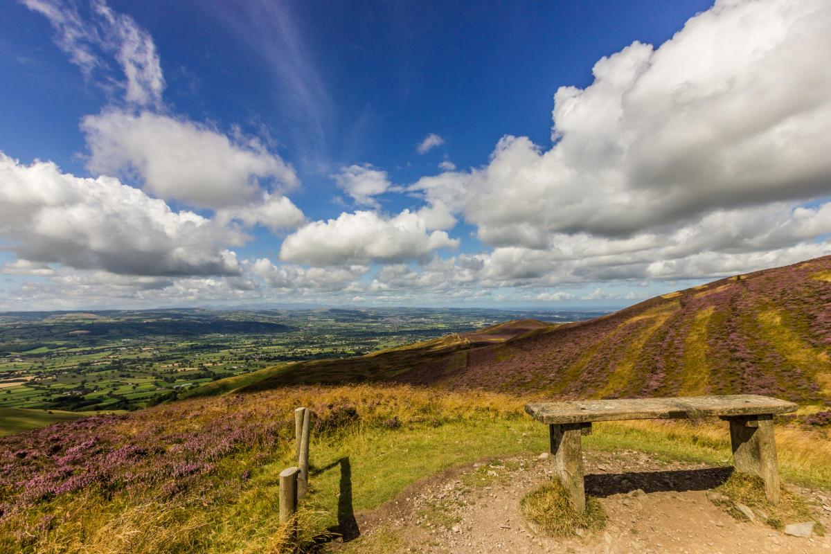
A STRENUOUS walk on the steep western slopes of Moel Famau high above the Vale of Clwyd. Superb views into the Vale and
across to the mountains of Snowdonia are the reward for such hard work. Footpaths are generally good, although a short section
on the descent to Moel y Gaer requires careful route finding.
Distance: 5½ miles
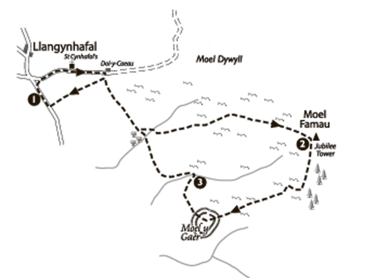
Start: Just to the south of the village of Llangynhafal there is a crossroads and about 200 yards south of this (on the lane to Hirwaen), there is a small layby with room for half a dozen cars.
The walk
1. On the opposite side of the lane and a few yards back towards Llangynhafal, take the signed path across a small field to enter
another lane. Turn right and follow the lane up to St Cynhafal's parish church. Pass the church and continue up the rising lane to a house ('Dol-yCaeau') on the left (about 500yards). A few yards before the house take the signed footpath on the right which shortly leads onto the open hillside. The path contours above fields on the right with wide views across the Vale of Clwyd.
Continue passing a striking Scot's pine on the right at one point. A little beyond this the path veers left away from the walled fields on the right and down into a small valley. Cross the stream and rise to a fork beside a fingerpost.
Turn left here and follow the rising footpath up through the bracken. As the angle eases the Jubilee Tower on the summit of Moel Famau
comes into view. Continue on the obvious path which, as you approach the summit, curves left to join the Offa's Dyke Path at a T junction on the broad whale back ridge. Turn right and rise steeply up to the summit.
From the summit you can enjoy one of the finest panoramas in northeast Wales, particularly west across the Vale of Clwyd and the Denbigh Moors to the peaks of Snowdonia on the far horizon. North and south the views are along the switchback ridge of the Clwydian
Range, while to the east lies the distant lowland of the Cheshire Plain, along with the Deeside and Merseyside industrial belts.
The ruined tower which crowns the highest point was built in 1810 to commemorate the 50th year of the reign of King George III. It was
originally designed in the Egyptian style to reach a height of 150 feet, but the plans were never fully carried out and the structure that
was built collapsed in 1862 following a series of gales. Attempts to restore the tower for Queen Victoria's Golden Jubilee in 1887 were a
failure and the modest structure which we now see is all that remains.
2. Take the Offa's Dyke Path south from the summit (signed 'Bwlch Penbarra'). After the initial steep descent the path levels with
conifer woods on the left. The next section down to Moel y Gaer hillfort needs careful route finding. Continue until a small heathery rise on the left obscures the trees briefly and there is a bench on the right (inscribed 'Tower View 1st April 2002 Tony Christopher'). A few yards further on turn right onto a narrow footpath through the heather.
This soon swings rightwards, back towards Moel Dywyll with its two summit cairns. At a point where the path becomes completely
level (about 150 yards from the bench), look for a very narrow but visible path on the left. This path soon begins to descend and Moel y
Gaer hillfort comes into view below. Continue the descent down through bracken to a broad saddle to enter the hillfort through a gap in the earthworks. In the centre of the enclosure a small stone cairn marks the highest point.
Like the other hillforts on the Clwydian Range, Moel y Gaer was constructed by Celtic tribes in the centuries before the Roman invasion and is unusual in being the only hillfort not situated on the main ridge itself. It is, however, easy to see why the site was chosen with
steep ground on three sides, the only approach is from the east via this narrow connecting ridge which would have been easy to defend.
Head northwest from the summit (towards the western end of the Vale of Clwyd where the hills meet the flat land) crossing the earthworks
and descending to a stile in the fence below.
Cross the stile and turn right around a large area of gorse, then bear diagonally-right down the sloping field to where fences meet the
stream in the bottom of the valley. At the bottom of the slope before the fence, turn right passing a waymarker post and continue
ahead to a second post. Turn sharp left here as directed between gorse on the left and the fence to the right to reach a gate. Go through
the gate and turn left over the stream to follow the footpath above a small bracken filled valley down to the left.
3. After a slight rise the path swings right to run beside walled fields on the left. Continue on this path eventually joining the outward
route just before the solitary Scot's pine seen earlier. Retrace the outward route but, just before the path joins the lane, bear left down to a
gate. Go through the gate and follow a sunken bridleway down to the lane where a right turn will take you back to the layby to complete the walk.
This walk was taken from the book Walking In The Clwydian Range by Carl Rogers, published by Mara Books.


Comments: Our rules
We want our comments to be a lively and valuable part of our community - a place where readers can debate and engage with the most important local issues. The ability to comment on our stories is a privilege, not a right, however, and that privilege may be withdrawn if it is abused or misused.
Please report any comments that break our rules.
Read the rules here