
A walk with spectacular views over two coastal hills and along a section of coastal path. Save this walk for good weather to fully appreciate the views.
Distance: 6½ miles
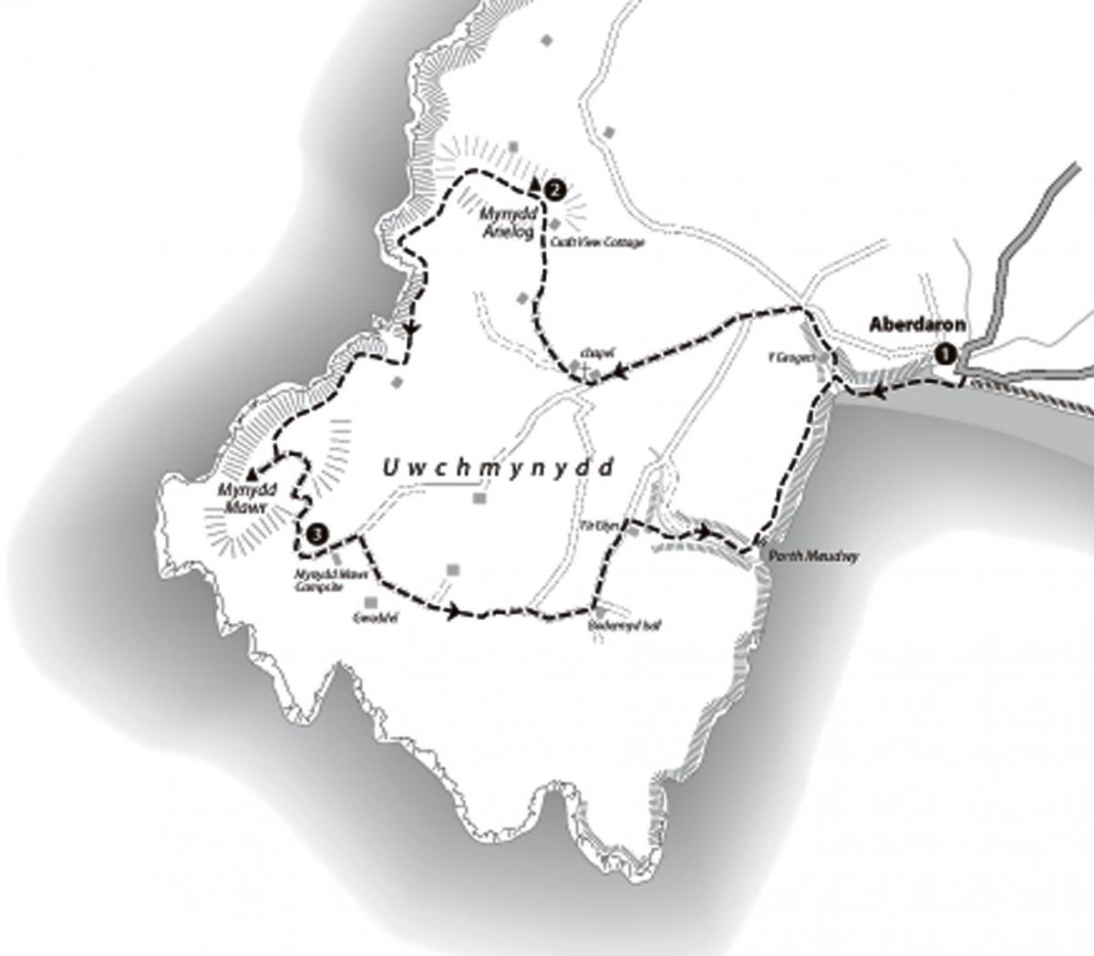
Start: Begin in Aberdaron where there is a large car park (fee payable) and WC facilities by the old bridge grid ref: 173 264. An alternative start could be made from point 3 where there is a free car park below Mynydd Mawr situated at the end of the narrow lane leading southwest from Aberdaron (Grid ref: 141 255). (Landranger 123, Explorer 253). Good pubs in Aberdaron, especially the Ty Newydd Hotel, tel: 01758 760207 (
).
The walk
1. Turn right out the car park, cross the old bridge and pass between buildings ahead to the beach. Turn right along the sand. Ford the shallow river which flows across the beach and continue to the far end of the bay. Go through the kissing gate and climb steps up to the cliff top coastal path. Turn right here and follow the path along a small valley. Cross a footbridge over the stream on the right and continue up the valley past a small cottage ('Y Grogen 1968') on the left to reach the lane. Turn left and where the lane forks shortly, keep left, signed 'Uwchmynydd 1'.
Follow the lane for just over ½ mile where there is a chapel on the right. Immediately after the chapel turn right down the cul-de-sac lane. In 100 yards or so bear right through a large field gate immediately after the driveway to a bungalow also on the right, signed 'Talcefnfoel'. Follow a grass track through the following fields and past a small isolated cottage ('Talcefnfoel') in a superb spot. Bear right past the cottage to follow a path between fields and through a small gate onto the open hillside.
Follow the good footpath ahead which rises beside the fence. At the top of the rise, keep ahead passing above and to the left of a cottage decorated with unusual iron sculptures ('Craft View Cottage') which enjoys a stunning view across western Lleyn. Turn left up one of
the many sheep paths which lead up to the summit of Mynydd Anelog.
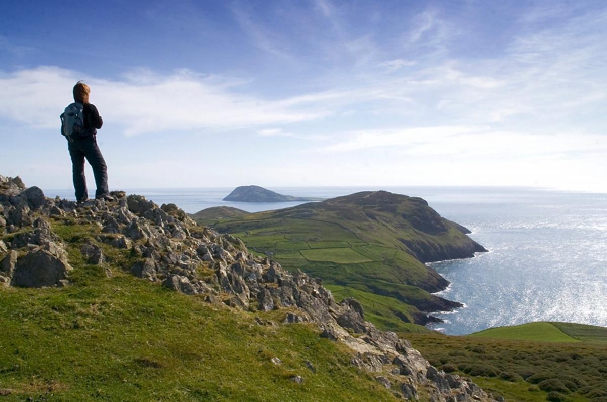
There are wide views from here across flat fields of Uwchmynydd to the island of Bardsey and past the wide bays at Aberdaron and Hell's Mouth. Northeast the view takes in the rocky coastline to Whistling Sands and beyond to the headland of Penrhyn Mawr near Porth Iago. The pointed tops of Yr Eifl and Carn Fadryn can be seen in the distance.
2. Head north (directly out to sea) on a visible path to a second small cairn (about 150 yards or so). From here make your way down the
southwest slopes (leftwards) heading for a stile visible to the right-hand side of fields below. There are many narrow sheep trails here to choose from. Walk beside the walled field on the left and cross the stile in the corner. Go ahead (ignore a path on the left) down through
gorse and bracken aiming for the right hand side of a field below.Walk along the outside edge of the field and at the outside corner you look down into the rocky inlet ahead. Turn left here and, keeping towards the upper edge of the slope (there is no formal route at the time of writing) walk around the inlet just below fields on the left.
About half way around the inlet, join a faint grass path or track which descends diagonally from the fields above (there is a small isolated cottage visible in the field above and ahead). Follow the path down to cross the stream by the National Trust board ('Porth Llanllawen'). Rise steeply beyond the stream and continue along the coastal slope. Go through a kissing gate in the top left-hand corner of the field and go ahead up a small field and through a second kissing gate. This leads onto the open hillside of Mynydd Mawr. Again, there are many paths but no formal route at the time of writing. Take a gently rising line directly ahead.
At the top of the rise walk down into a broad shallow hollow or saddle and bear left. Rise to the right of a narrow walled field ahead to join the concrete road which leads up onto Mynydd Mawr. Turn right up the road and you will soon be on the summit with its superb views of the surrounding coast. A good place for a break. To continue, follow the concrete road down to the parking area.
3. Beyond the parking area follow the lane over the cattle grid and out of the National Trust land at 'Braich y Pwll'. Pass a farmhouse ('Ty Mawr') and in about 75 yards take the signed footpath down the farm road to 'Gweddel'. After the first field pass the farm on the right and continue ahead along the track through more fields. Where the track swings left to a second farm, keep ahead bearing half-right across the field to a stile by a field gate. Cross the stile and head diagonally across the following field to a stile in the opposite corner. Cross this stile
and go left to a large gate which leads onto a farm track.
Walk ahead down the farm road passing a pool on the left. Continue along the lane ignoring a left fork and at farm buildings ('Bodermyd Isaf') ignore two lanes on the right. At the next farm and caravan site ('Tir Glyn') turn right into the farmyard and go ahead past the WC
block and follow a footpath down steps into a small valley. Cross a stream in the bottom of the valley and follow the footpath up to an unsurfaced access road.
Turn right and follow the road down to a small cove ('Porth Meudwy') where there are usually several fishing boats moored. Turn left up the steps and follow the coastal path back to Aberdaron retracing the outward journey along the beach to complete the walk.
This walk has been taken from the best selling book: Walks on the Lleyn Peninsula by Carl Rogers, published by Mara Books. (ISBN 978-1-902512-00-6). Copies can be ordered from bookshops or purchased online at:
www.northerneyebooks.co.uk

Comments: Our rules
We want our comments to be a lively and valuable part of our community - a place where readers can debate and engage with the most important local issues. The ability to comment on our stories is a privilege, not a right, however, and that privilege may be withdrawn if it is abused or misused.
Please report any comments that break our rules.
Read the rules here