
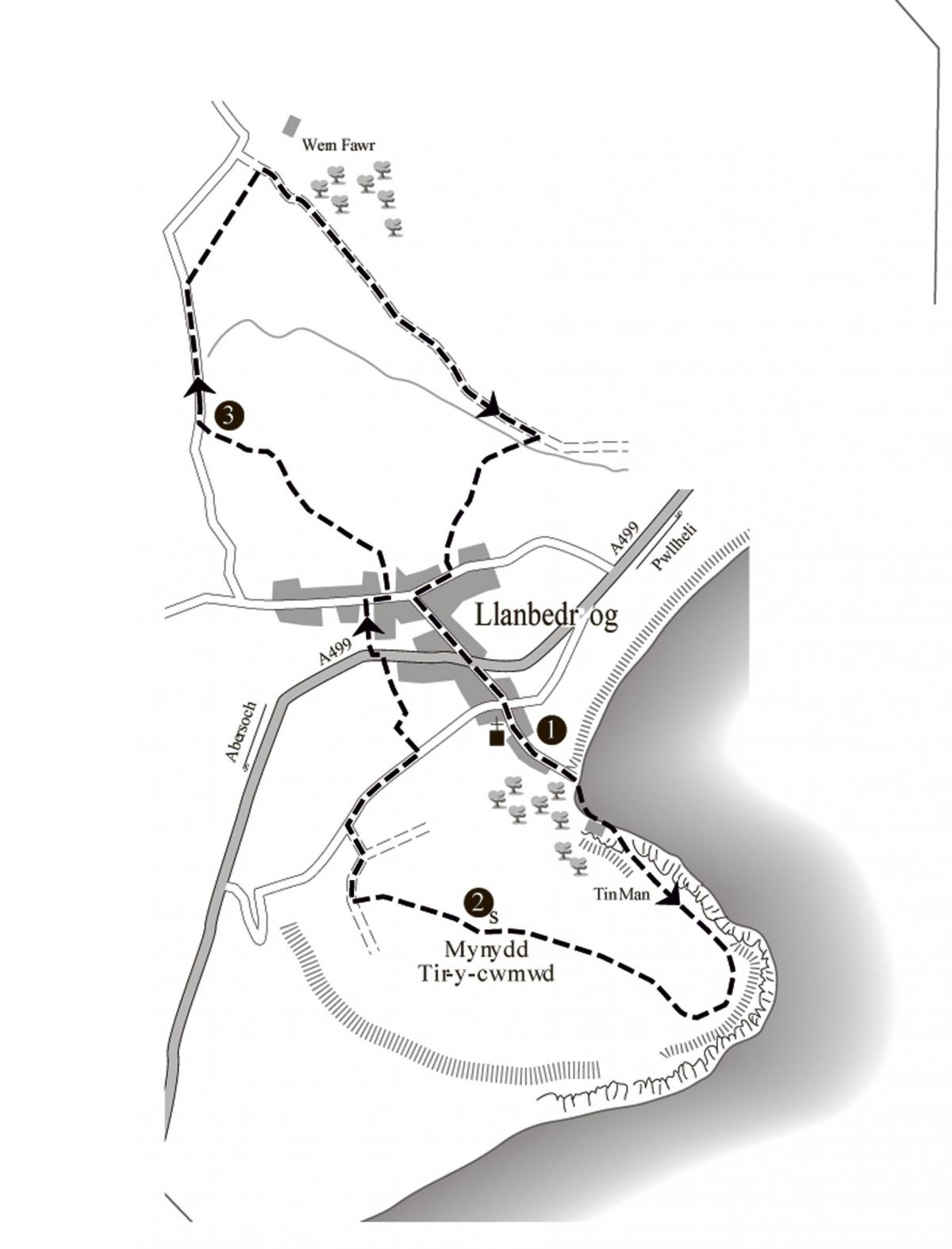
Llanbedrog
A steep scramble up onto the open headland of Mynydd Tir-ycwmwd with wide views along the coast in both directions is followed by easy walking through farmland and along quiet lanes. Paths are generally good.
Distance: 4 3/4 miles
Start: There is a large National Trust beach car park just off the A499 in Llanbedrog village (parking fee).
Grid ref: 331 314 (Landranger 123, Explorer 253).
The walk
1. From the back of the car park take steps down to the lane and turn left to the beach. Walk down onto the sand and bear right across the stream. Walk along the beach past a stone cottage ('Foxhole') and continue along the rocky shore passing a second cottage (it may not be possible to do this during the highest tides). About 25 yards beyond the cottage turn right up a flight of steps which lead steeply (very) through the trees to the top of the cliffs overlooking the bay (signed 'Mynydd Tir Cwmwd').
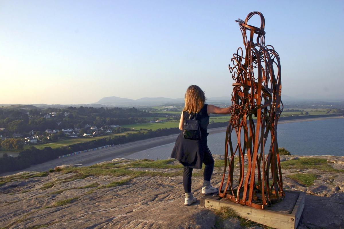
At the top of the cliffs there is a grand view of the village and bay stretching east towards Pwllheli, while the hills of Garn Boduan, Carn Fadryn and Yr Eifl are backed by the higher summits of Snowdonia to the northeast. The curious sculpture here was created to commemorate the new millennium and replaced the 'Tin Man' by local artist Simon Van de Put which did not stand the Welsh climate very well.
Follow the obvious path past the millennium sculpture and continue round the headland.
As you reach the blunt end of the headland Saint Tudwal's Islands come into view ahead and as you continue they disappear and
appear again before you reach a pronounced junction where five footpaths meet: a path sharp right which heads back towards the millennium sculpture; the main footpath veers left (coastal path); there is a narrower path straight ahead and a path which bears right. Take this last path which heads up to the summit where there is a triangulation pillar and a large view finder erected by Llanbedrog Community Council.
From here, the highest point on the headland, there is a full 360 degree panorama taking in the curving bays to the east as already
described, and west towards Abersoch and St Tudwal's Island. The northern arc takes in the hills of Mynydd Rhiw beyond Hell's Mouth, the little hill of Foel Fawr with its disused windmill, Carn Fadryn, Garn Boduan, Yr Eifl and finally the mountains of Snowdonia on the skyline. In clear conditions the Rhinog hills and Cadair Idris can be seen across Cardigan Bay. If the clarity is exceptional, the line of the bay can be followed right down to St David's Head in Pembrokeshire.
These sheltered waters may look inviting on a calm summer day but they hide one of Britain's major shipping hazards, a feature which claimed literally hundreds of vessels during the 18th and 19th centuries - Sarn Badrig or 'Saint Patrick's Causeway'. This curious feature comprises a ridge of stones and rock debris which run for over 14 miles in a southwest direction from a point about a mile offshore near Harlech. Ships driven into Cardigan Bay by a southwesterly wind became trapped and many foundered on the causeway.
2. From the triangulation pillar a broad path heads northwest (almost directly towards Carn Fadryn and to the right of the hill
with the tower). At a T junction with a track near the edge of the common turn right and where the track joins a tarmac lane (at a fork) bear left down the hill. Lower down join the old lane from Llanbedrog at a T junction. Turn right here and after about 350 yards turn left along an access track signed as a public footpath (opposite a signed footpath on the right). Follow the track as it
turns right past cottages and then left between bungalows. At the next right turn ('Pendyffryn' ahead) continue straight ahead on a footpath which descends into the trees to the A499.
Cross the road, pass through a kissing gate directly opposite and follow the rising footpath between gardens higher up. At a short access road bear right and continue to the road. Take the signed footpath opposite beside the school to enter fields. The path across the field is fenced and leads to a small gate. Go through the gate and walk ahead on a path along a small bracken covered valley. Go through a kissing gate in the wall on the right and continue along the valley.
At the far end of the valley bear left through a kissing gate near a caravan site and climb steps up the bank. Follow the footpath ahead to the lane.
3. Turn right along the lane and after about 500 yards look for a stile beside a field gate where power lines cross the road. Head half-left through two large fields keeping beside the hedge to enter an unmetalled farm track by a ladder stile. (If you miss this field path continue along the lane and turn right down the drive to 'Wern Fawr'.
Where the drive turns left go ahead along the farm track.) Turn right and follow the track between fields for about ½ mile.
As you approach Llanbedrog the track overlooks a small valley on the right. Immediately before a farm track joins from the left, turn sharp right onto a descending path. Cross a stile and small stream at the bottom of the slope and rise directly up the following field to a kissing gate. Go through the gate and continue ahead along field edges (stiles) to a narrow access road.
Turn left here, then right at the next junction. Follow this road to a T junction with the B4413. Turn left down the hill and cross the main road by the pub ('Glyn-Y-Weddw Ty du'). Walk down the lane opposite back to the car park to complete the walk.
The Official Guide to the Lleyn Peninsula section of the Wales Coast Path (ISBN 978-908632-24-1)
This walk has been taken from the book: 'Top 10 Walks on the Wales Coast Path: Lleyn Peninsula' by Carl Rogers, published by Northern Eye Books, price £4.99. (ISBN 978-1-908632-12-8). One in a series of 10 guidebooks to circular walks along the entire Welsh coast. Copies can be ordered from bookshops or purchased online at: www.northerneyebooks.co.uk


Comments: Our rules
We want our comments to be a lively and valuable part of our community - a place where readers can debate and engage with the most important local issues. The ability to comment on our stories is a privilege, not a right, however, and that privilege may be withdrawn if it is abused or misused.
Please report any comments that break our rules.
Read the rules here